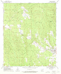
1970 Map of Delight
USGS Topo · Published 1971About this map
Delight serves as the primary hub in this corner of Pike County, situated where the Missouri Pacific Railroad cuts through the landscape. The settlement patterns follow the creek valleys and rail corridors, with Pike City to the north and the smaller community of Steltown positioned along the tracks. The terrain is defined by a dense network of waterways, including Saline Creek, Wolf Creek, and Strawberry Creek, which likely shaped the early timber and agricultural development of the region.
Find a feature on this map
43 named features on this map. Tap any name to fly to it.
Don’t see what you’re looking for? This feature index may not catch every label — zoom into the map to look around manually.
Map Details
Editions of this 1970 Delight Map
2 editions found
Other maps of this area

1901 · Gurdon
USGS Topo · 1:125,000

1906 · Caddo Gap
USGS Topo · 1:125,000

1943 · Antoine
USGS Topo · 1:62,500

1951 · Pisgah
USGS Topo · 1:24,000

1951 · McCaskill
USGS Topo · 1:24,000

1953 · El Dorado
USGS Topo · 1:250,000

1955 · Little Rock
USGS Topo · 1:250,000

1956 · Little Rock
USGS Topo · 1:250,000

1957 · El Dorado
USGS Topo · 1:250,000

1958 · El Dorado
USGS Topo · 1:250,000