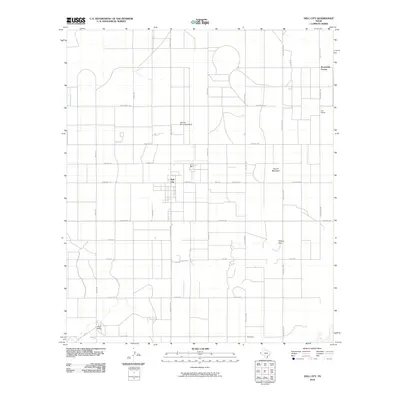
2010 Map of Dell City
USGS Topo · Published 2010About this map
The high desert agricultural hub of Dell City serves as the focal point for this West Texas landscape, defined by a rigid grid of ranch roads and irrigation-dependent land use. Established in the late 1940s after the discovery of a vast underground aquifer, the community is surrounded by expansive ranching operations such as List Ranch to the east and Lynch Ranch to the southwest. The presence of the Dell City Municipal Airport and a network of arterial routes like Ranch Rd 1437 and Fm 2249 underscores the area's role as a remote service center. Distinctive geographic markers like Round Mountain and the Wilcox Hills break the horizontal expanse of the salt basin floor, while named junctions like Brownfield Corner pinpoint key intersections in the regional transit network.
Find a feature on this map
29 named features on this map. Tap any name to fly to it.
Don’t see what you’re looking for? This feature index may not catch every label — zoom into the map to look around manually.
Map Details
Editions of this 2010 Dell City Map
This is the sole edition of this map. No revisions or reprints were ever made.
Other maps of this area

1951 · Dell City
USGS Topo · 1:62,500

1954 · Carlsbad
USGS Topo · 1:250,000

1954 · Van Horn
USGS Topo · 1:250,000

1955 · Cerro Diablo
USGS Topo · 1:62,500

1958 · Van Horn
USGS Topo · 1:250,000

1958 · Carlsbad
USGS Topo · 1:250,000
1969 · Cienega School
USGS Topo · 1:24,000
1969 · Culp Draw
USGS Topo · 1:24,000
1970 · Shiloh Hills SE
USGS Topo · 1:24,000

1979 · Crow Flats
USGS Topo · 1:100,000