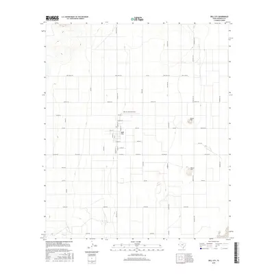
2016 Map of Dell City
USGS Topo · Published 2016About this map
Dell City serves as the focal point of this arid Hudspeth County landscape, characterized by a structured grid of ranch roads and irrigation-driven settlement. The town's layout is clearly defined by local thoroughfares such as Main St, Lee St, and E School Rd, while the Dell City Municipal Airport and Airstrip St emphasize the area's reliance on aerial connectivity. Beyond the town center, the terrain is punctuated by isolated elevations like Round Mtn and the Wilcox Hills, which break the flat horizon of the Salt Basin. This 2016 survey illustrates the persistent ranching and farming infrastructure of the Trans-Pecos region, naming long-established corridors such as Jones Ranch Rd, Judge Ziler Rd, and Snodgrass Rd that tie these remote properties to the larger network of Ranch Rd 1437 and Ranch Rd 1576.
Find a feature on this map
40 named features on this map. Tap any name to fly to it.
Don’t see what you’re looking for? This feature index may not catch every label — zoom into the map to look around manually.
Map Details
Editions of this 2016 Dell City Map
This is the sole edition of this map. No revisions or reprints were ever made.
Other maps of this area

1951 · Dell City
USGS Topo · 1:62,500

1954 · Carlsbad
USGS Topo · 1:250,000

1954 · Van Horn
USGS Topo · 1:250,000

1955 · Cerro Diablo
USGS Topo · 1:62,500

1958 · Van Horn
USGS Topo · 1:250,000

1958 · Carlsbad
USGS Topo · 1:250,000
1969 · Cienega School
USGS Topo · 1:24,000
1969 · Culp Draw
USGS Topo · 1:24,000
1970 · Shiloh Hills SE
USGS Topo · 1:24,000

1979 · Crow Flats
USGS Topo · 1:100,000