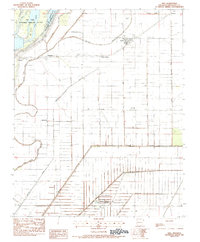
1983 Map of Dell
USGS Topo · Published 1984About this map
Big Lake National Wildlife Refuge dominates the northwest corner of this Mississippi County landscape, where the Little River and Left Hand Chute navigate a complex of islands and wetlands. The surrounding terrain is defined by a dense, rectilinear grid of drainage infrastructure, including Ditch No 21 and Ditch No 6, which converted former swamplands into productive agricultural fields. These ditches follow the section lines, shaping the development of rural crossroads and rail-aligned settlements.
Find a feature on this map
41 named features on this map. Tap any name to fly to it.
Don’t see what you’re looking for? This feature index may not catch every label — zoom into the map to look around manually.
Map Details
Editions of this 1983 Dell Map
This is the sole edition of this map. No revisions or reprints were ever made.
Other maps of this area

1939 · Blytheville
USGS Topo · 1:62,500

1939 · Evadale
USGS Topo · 1:62,500

1941 · Manila
USGS Topo · 1:62,500

1953 · Memphis
USGS Topo · 1:250,000

1955 · Blytheville
USGS Topo · 1:62,500

1956 · Manila
USGS Topo · 1:62,500

1956 · Evadale
USGS Topo · 1:62,500

1956 · Memphis
USGS Topo · 1:250,000

1956 · Blytheville
USGS Topo · 1:250,000

1959 · Blytheville
USGS Topo · 1:250,000