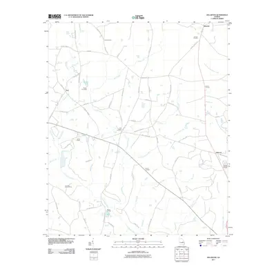
2011 Map of Dellwood
USGS Topo · Published 2011About this map
Blundale, Tom, and Dellwood anchor this part of rural Georgia, where a dense network of country roads connects family settlements and burial grounds. The landscape is defined by the headwaters and branches of several coastal plain river systems, including the Little Ohoopee River, Sardis Creek, and the prongs of the Canoochee Creek. Local family history is preserved through numerous cemeteries like Pollett Cemetery, Moxley Cemetery, and Townsend-Gunn Cemetery. Small-scale agricultural water management is evident at Minton Pond and Mixon Lake, both featuring labeled dams. The layout of Darlas Airport and the transition from local routes like Pinetucky Rd to state-maintained corridors illustrates the intersection of traditional land use and modern infrastructure in Johnson County.
Find a feature on this map
62 named features on this map. Tap any name to fly to it.
Don’t see what you’re looking for? This feature index may not catch every label — zoom into the map to look around manually.
Map Details
Editions of this 2011 Dellwood Map
This is the sole edition of this map. No revisions or reprints were ever made.
Other maps of this area

1957 · Macon
USGS Topo · 1:250,000

1958 · Macon
USGS Topo · 1:250,000

1964 · Macon
USGS Topo · 1:250,000

1971 · Norristown
USGS Topo · 1:24,000

1971 · Swainsboro
USGS Topo · 1:24,000

1971 · Dellwood
USGS Topo · 1:24,000

1971 · Summertown
USGS Topo · 1:24,000
1973 · Davisboro SE
USGS Topo · 1:24,000

1973 · Colemans Lake
USGS Topo · 1:24,000
1973 · Wadley
USGS Topo · 1:24,000