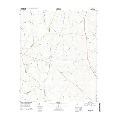
2014 Map of Dellwood
USGS Topo · Published 2014About this map
The Little Ohoopee River and its numerous tributaries, including Sardis Cr, Bruner Cr, and Flat Cr, define the drainage patterns along the boundary of Johnson Co and Emanuel Co. Small agricultural communities and family settlements are connected by a network of rural roads like Pinetucky Rd and Minton Chapel Rd. The landscape is dotted with several distinct burial sites such as Pollett Cem, Townsend Gunn Cem, and Moxley Cem, which serve as vital landmarks for local genealogists. The settlement of Blundale sits in the northern section, while Dellwood anchors the southeast, highlighting a pattern of dispersed rural living. Near the center of the map, Oak Chapel and its adjacent Oak Chapel Cem stand as a community focal point. Unusual for such a rural area, Daria's Airport provides a small aviation footprint amidst the creeks and timberlands.
Find a feature on this map
80 named features on this map. Tap any name to fly to it.
Don’t see what you’re looking for? This feature index may not catch every label — zoom into the map to look around manually.
Map Details
Editions of this 2014 Dellwood Map
This is the sole edition of this map. No revisions or reprints were ever made.
Other maps of this area

1957 · Macon
USGS Topo · 1:250,000

1958 · Macon
USGS Topo · 1:250,000

1964 · Macon
USGS Topo · 1:250,000

1971 · Norristown
USGS Topo · 1:24,000

1971 · Swainsboro
USGS Topo · 1:24,000

1971 · Dellwood
USGS Topo · 1:24,000

1971 · Summertown
USGS Topo · 1:24,000
1973 · Davisboro SE
USGS Topo · 1:24,000

1973 · Colemans Lake
USGS Topo · 1:24,000
1973 · Wadley
USGS Topo · 1:24,000