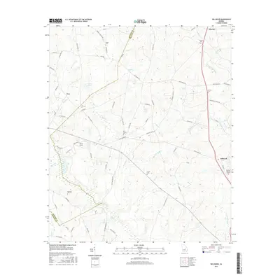
2017 Map of Dellwood
USGS Topo · Published 2017About this map
The Little Ohoopee River and the upper reaches of N Prong Canoochee Cr define this rural landscape on the border of Emanuel and Johnson Counties. This area is characterized by a network of family and community landmarks, including several small cemeteries such as Pollett Cem, Moxley Cem, and the Townsend-Gunn Cem. The small settlements of Blundale, Tom, and Dellwood serve as local anchors connected by an intricate web of timber and farm roads like Pinetucky Rd and Page Garrett Rd. Of particular interest to researchers is the concentration of localized religious and family sites, including Oak Chapel Cem and Bithynia Cem, alongside modern rural infrastructure like Daria's Airport. The drainage patterns of Sardis Cr and Rocky Cr reveal the low-lying, creek-cut nature of the terrain, illustrating how historical development followed these persistent watercourses through the Georgia pine woods.
Find a feature on this map
75 named features on this map. Tap any name to fly to it.
Don’t see what you’re looking for? This feature index may not catch every label — zoom into the map to look around manually.
Map Details
Editions of this 2017 Dellwood Map
This is the sole edition of this map. No revisions or reprints were ever made.
Other maps of this area

1957 · Macon
USGS Topo · 1:250,000

1958 · Macon
USGS Topo · 1:250,000

1964 · Macon
USGS Topo · 1:250,000

1971 · Norristown
USGS Topo · 1:24,000

1971 · Swainsboro
USGS Topo · 1:24,000

1971 · Dellwood
USGS Topo · 1:24,000

1971 · Summertown
USGS Topo · 1:24,000
1973 · Davisboro SE
USGS Topo · 1:24,000

1973 · Colemans Lake
USGS Topo · 1:24,000
1973 · Wadley
USGS Topo · 1:24,000