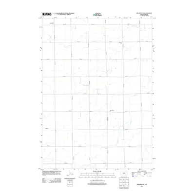
2012 Map of Delmont SE
USGS Topo · Published 2012About this map
Saint Marys Cem anchors the northwestern corner of this prairie landscape in Douglas County, where a strictly geometric grid of section-line roads defines the rural geography. The terrain is subtly shaped by the branching drainages of N Br Dry Cr and S Br Dry Cr, which weave through the agricultural parcels. This 2012 survey documents a persistent pattern of rural heritage, marked by small, distributed burial grounds including Elgenfield Cem and Hoffnungberg Cem. The map provides a detailed view of the township's infrastructure, from the long stretches of 407th Ave to the east-west corridors of 282nd St, showing how the land has been organized for farming and community preservation over decades.
Find a feature on this map
20 named features on this map. Tap any name to fly to it.
Don’t see what you’re looking for? This feature index may not catch every label — zoom into the map to look around manually.
Map Details
Editions of this 2012 Delmont SE Map
This is the sole edition of this map. No revisions or reprints were ever made.
Other maps of this area

1898 · Olivet
USGS Topo · 1:125,000

1955 · Sioux Falls
USGS Topo · 1:250,000

1955 · Mitchell
USGS Topo · 1:250,000

1958 · Sioux Falls
USGS Topo · 1:250,000

1959 · Mitchell
USGS Topo · 1:250,000

1977 · Oak Hollow
USGS Topo · 1:24,000

1978 · Oak Hollow
USGS Topo · 1:24,000
1978 · Greenwood Colony
USGS Topo · 1:24,000
1978 · Tripp
USGS Topo · 1:24,000

1979 · Delmont
USGS Topo · 1:24,000
Featured Places
- East Choteau Township, SD
- Lincoln Township, SD
- Belmont Township, SD
- Kulm Township, SD
- Oak Hollow Township, SD