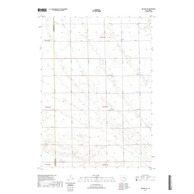
2017 Map of Delmont SE
USGS Topo · Published 2017About this map
Agricultural lands across the border of Douglas and Hutchinson counties define this 2017 survey area. The landscape is marked by the branching headwaters of Dry Creek, including N Br Dry Cr in the northern townships and S Br Dry Cr farther south. This section of South Dakota preserves a rural character rooted in its early settlement, evident in the distributed country burial grounds such as Saint Marys Cem and Elgenfield Cem. Further south, the Hoffnungsberg Cem serves as a local landmark amidst a regular grid of section-line roads. The map illustrates a strictly rectilinear transport network where numbered avenues like 407th Ave intersect with roads such as 282nd St, providing a clear record of the modern prairie land division system.
Find a feature on this map
27 named features on this map. Tap any name to fly to it.
Don’t see what you’re looking for? This feature index may not catch every label — zoom into the map to look around manually.
Map Details
Editions of this 2017 Delmont SE Map
This is the sole edition of this map. No revisions or reprints were ever made.
Other maps of this area

1898 · Olivet
USGS Topo · 1:125,000

1955 · Sioux Falls
USGS Topo · 1:250,000

1955 · Mitchell
USGS Topo · 1:250,000

1958 · Sioux Falls
USGS Topo · 1:250,000

1959 · Mitchell
USGS Topo · 1:250,000

1977 · Oak Hollow
USGS Topo · 1:24,000

1978 · Oak Hollow
USGS Topo · 1:24,000
1978 · Greenwood Colony
USGS Topo · 1:24,000
1978 · Tripp
USGS Topo · 1:24,000

1979 · Delmont
USGS Topo · 1:24,000
Featured Places
- East Choteau Township, SD
- Lincoln Township, SD
- Belmont Township, SD
- Kulm Township, SD
- Oak Hollow Township, SD