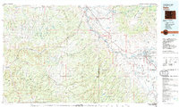
1980 Map of Delta
USGS Topo · Published 1980About this map
The Gunnison River and Uncompahgre River converge in this western Colorado landscape, providing the lifeblood for the agricultural and transport corridor surrounding Delta. This 1980 edition reveals the extensive network of irrigation and water management essential to the high desert, including the Granby Reservoirs and Dugger Reservoir. The rail-driven economy is evident through the path of the Denver and Rio Grande Western railroad, which follows the river valleys through settlements like Whitewater and Bridgeport.
Find a feature on this map
183 named features on this map. Tap any name to fly to it.
Don’t see what you’re looking for? This feature index may not catch every label — zoom into the map to look around manually.
Map Details
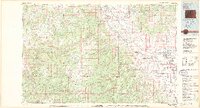
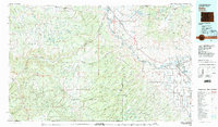
Editions of this 1980 Delta Map
3 editions found
Other maps of this area

1885 · East Tavaputs
USGS Topo · 1:250,000

1885 · La Sal
USGS Topo · 1:250,000

1909 · Montrose
USGS Topo · 1:125,000

1911 · Montrose
USGS Topo · 1:125,000

1916 · Paradox Valley
USGS Topo · 1:125,000

1922 · Paradox Valley
USGS Topo · 1:125,000

1934 · Colorado National Monument
USGS Topo · 1:24,000

1948 · Roc Creek
USGS Topo · 1:24,000
1949 · Roc Creek
USGS Topo · 1:24,000

1949 · Juanita Arch
USGS Topo · 1:24,000