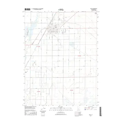
2017 Map of Delta
USGS Topo · Published 2017About this map
The Sevier River and a sophisticated network of man-made waterways define this agricultural region in Millard County. The settlement of Delta serves as the primary hub, surrounded by an intricate system of irrigation infrastructure including the Lyman Ditch, Melville E Canal, and Jones Ditch. This geography illustrates the intensive water management required to sustain desert farming, with the Gunnison Bend Reservoir providing a significant local landmark and water source. Further south, the smaller community of Oasis sits near its own namesake Oasis Canal. Genealogists and local historians can locate specific sites such as the Delta City Cem and the Oasis Cem, while transportation is represented by the Delta Municipal Airport and a rigid grid of county roads that carve the landscape into sections, reflecting the township and range divisions of t17s r7w and t18s r6w.
Find a feature on this map
63 named features on this map. Tap any name to fly to it.
Don’t see what you’re looking for? This feature index may not catch every label — zoom into the map to look around manually.
Map Details
Editions of this 2017 Delta Map
This is the sole edition of this map. No revisions or reprints were ever made.
Other maps of this area

1885 · Sevier Desert
USGS Topo · 1:250,000

1951 · Oak City
USGS Topo · 1:62,500

1953 · Delta
USGS Topo · 1:250,000

1958 · Delta
USGS Topo · 1:250,000

1962 · Delta
USGS Topo · 1:250,000

1962 · Holden
USGS Topo · 1:62,500

1962 · Delta
USGS Topo · 1:62,500

1971 · Pavant Butte North
USGS Topo · 1:24,000

1971 · Sunstone Knoll
USGS Topo · 1:24,000
1985 · Harding
USGS Topo · 1:24,000