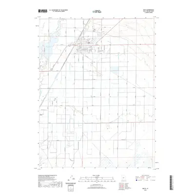
2020 Map of Delta
USGS Topo · Published 2020About this map
Delta and the smaller settlement of Oasis anchor this Millard County landscape, where the managed waters of the Sevier River sustain a complex agricultural grid. The importance of irrigation to this Great Basin community is evidenced by a dense network of man-made waterways, including the Melville E Canal, Melville W Canal, and the Deseret Canal, which distribute water from the Gunnison Bend Reservoir. Local heritage and genealogy are grounded in landmarks such as the Delta City Cem north of the main town and the Oasis Cem located between the river and the townsite of Oasis. The map's detailed road system, featuring names like N Sugar Factory Rd, alludes to the region's industrial agricultural roots. Beyond the main settlements, family-named water features like Lyman Ditch, Styler Ditch, and Eliason Jensen Ditch suggest a long history of water rights and land ownership essential to desert life.
Find a feature on this map
112 named features on this map. Tap any name to fly to it.
Don’t see what you’re looking for? This feature index may not catch every label — zoom into the map to look around manually.
Map Details
Editions of this 2020 Delta Map
This is the sole edition of this map. No revisions or reprints were ever made.
Other maps of this area

1885 · Sevier Desert
USGS Topo · 1:250,000

1951 · Oak City
USGS Topo · 1:62,500

1953 · Delta
USGS Topo · 1:250,000

1958 · Delta
USGS Topo · 1:250,000

1962 · Delta
USGS Topo · 1:250,000

1962 · Holden
USGS Topo · 1:62,500

1962 · Delta
USGS Topo · 1:62,500

1971 · Pavant Butte North
USGS Topo · 1:24,000

1971 · Sunstone Knoll
USGS Topo · 1:24,000
1985 · Harding
USGS Topo · 1:24,000