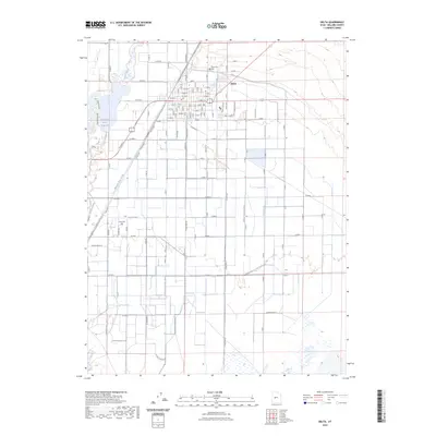
2023 Map of Delta
USGS Topo · Published 2023About this map
Delta stands as a hub of water management and rail transportation in this arid stretch of Millard County. The landscape is defined by an intricate network of irrigation infrastructure, including the Melville-East Canal, Melville West Canal, and Canal C, which divert water from the Sevier River and the Gunnison Bend Reservoir. These engineering efforts transformed the desert floor into a grid of agricultural blocks, supported by local family-named ditches such as the Styler Ditch and Eliason Jensen Ditch. The Union Pacific Railroad cuts a diagonal path through the town center, underscoring the community's historical reliance on freight logistics. Local genealogy is anchored by the Delta City Cem at the northern edge of town and the Oasis Cem located to the southwest, serving the rural clusters of homes that line the rigid township and range roads.
Find a feature on this map
114 named features on this map. Tap any name to fly to it.
Don’t see what you’re looking for? This feature index may not catch every label — zoom into the map to look around manually.
Map Details
Editions of this 2023 Delta Map
This is the sole edition of this map. No revisions or reprints were ever made.
Other maps of this area

1885 · Sevier Desert
USGS Topo · 1:250,000

1951 · Oak City
USGS Topo · 1:62,500

1953 · Delta
USGS Topo · 1:250,000

1958 · Delta
USGS Topo · 1:250,000

1962 · Delta
USGS Topo · 1:250,000

1962 · Holden
USGS Topo · 1:62,500

1962 · Delta
USGS Topo · 1:62,500

1971 · Pavant Butte North
USGS Topo · 1:24,000

1971 · Sunstone Knoll
USGS Topo · 1:24,000
1985 · Harding
USGS Topo · 1:24,000