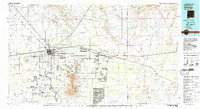
1982 Map of Deming
USGS Topo · Published 1983About this map
The high desert landscape of Luna County and Doña Ana County centers on Deming, a pivotal junction where the Atxison Topeka and Santa Fe and Southern Pacific railroads converge. This early 1980s topographic study captures the region's transition from historical frontier outposts to modern industrial and military use. To the north, the Fort Cummings (Ruins) lie near the base of the Cookes Range, marking a nineteenth-century landmark on the trail through the desert.
Find a feature on this map
62 named features on this map. Tap any name to fly to it.
Don’t see what you’re looking for? This feature index may not catch every label — zoom into the map to look around manually.
Map Details
Editions of this 1982 Deming Map
2 editions found
Other maps of this area

1891 · Las Cruces
USGS Topo · 1:125,000

1893 · Las Cruces
USGS Topo · 1:125,000

1899 · Deming
USGS Topo · 1:125,000

1909 · Silver City
USGS Topo · 1:125,000

1915 · Deming
USGS Topo · 1:125,000

1916 · Tonuco
USGS Topo · 1:125,000

1917 · Hermanas
USGS Topo · 1:62,500

1917 · Camel Mountain
USGS Topo · 1:62,500

1917 · Columbus
USGS Topo · 1:62,500

1917 · Noria
USGS Topo · 1:62,500