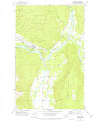
1972 Map of Deming
USGS Topo · Published 1977About this map
The confluence of the three forks of the Nooksack River dominates this landscape on the western flank of Sumas Mountain. This survey captures the valley settlements of Deming, Van Zandt, and Clipper during the early 1970s, linked by the Burlington Northern railroad and roads like Mosquito Lake Road. The drainage patterns of the North Fork, Middle Fork, and South Fork create a complex lowland environment defined by features like Black Slough and Mud Lake, contrasted against the steep slopes of Smith Peak and the precarious Devils Slide. Local history is anchored by the Mt Hope Cem and the Welcome Grange Hall, reflecting the community's rural social structure. Numerous gravel pits and quarries along the riverbanks indicate the area's ongoing extraction industry and its role in supporting the region's infrastructure.
Find a feature on this map
51 named features on this map. Tap any name to fly to it.
Don’t see what you’re looking for? This feature index may not catch every label — zoom into the map to look around manually.
Map Details
Editions of this 1972 Deming Map
2 editions found
Other maps of this area

1906 · Sumas
USGS Topo · 1:62,500

1908 · Sumas
USGS Topo · 1:62,500

1918 · Samish Lake
USGS Topo · 1:62,500

1919 · Van Zandt
USGS Topo · 1:62,500

1921 · Wickersham
USGS Topo · 1:62,500

1951 · Wickersham
USGS Topo · 1:62,500

1951 · Van Zandt
USGS Topo · 1:62,500

1952 · Lake Whatcom
USGS Topo · 1:24,000

1952 · Lawrence
USGS Topo · 1:24,000

1952 · Sumas
USGS Topo · 1:24,000