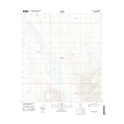
2015 Map of Denali C-1 NE
USGS Topo · Published 2015About this map
Denali National Park encompasses the majority of this landscape, where the braided channels of the Toklat River flow northward through a wide valley. The river system is a defining topographic element, creating a broad gravel floodplain that contrasts with the rising elevations to the east. The Wyoming Hills dominate the southeastern portion of the map, representing a significant upland area where numerous small drainages originate. Among these is Wigand Cr, which winds through the eastern hills. This 2015 survey illustrates a wilderness landscape largely defined by its natural hydrology and high-altitude relief, with the river's shifting course and the surrounding peaks remaining the primary features of the interior Alaskan terrain.
Find a feature on this map
10 named features on this map. Tap any name to fly to it.
Don’t see what you’re looking for? This feature index may not catch every label — zoom into the map to look around manually.
Map Details
Editions of this 2015 Denali C-1 NE Map
This is the sole edition of this map. No revisions or reprints were ever made.
Other maps of this area

1951 · Healy
USGS Topo · 1:250,000

1951 · Mount McKinley D-1
USGS Topo · 1:63,360

1951 · Healy D-6
USGS Topo · 1:63,360

1952 · Mount McKinley
USGS Topo · 1:250,000

1952 · Mount McKinley C-1
USGS Topo · 1:63,360

1954 · Healy C-6
USGS Topo · 1:63,360

1954 · Mount McKinley D-1
USGS Topo · 1:63,360

1954 · Mount McKinley C-1
USGS Topo · 1:63,360
1954 · Healy D-6
USGS Topo · 1:63,360

1956 · Healy
USGS Topo · 1:250,000