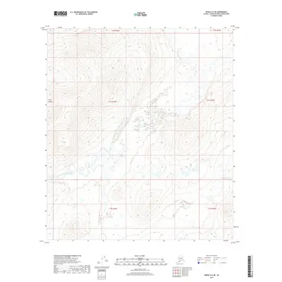
2017 Map of Denali D-6 NE
USGS Topo · Published 2017About this map
The North Fork Kuskokwim River defines this sub-arctic terrain, meandering across a landscape shaped by glacial and alluvial forces. The river's complex hydrological patterns are evident in the numerous oxbow lakes and abandoned channels that mark its course through the interior of Alaska. This 2017 study illustrates the drainage basin of the N Fork Kuskokwim River as it passes through the vast Unorganized Borough, providing a detailed record of the shoreline and water levels as they existed in the early 21st century. The map is primarily a record of natural topography and hydrological features, showing the river's path through undeveloped wilderness where human infrastructure is absent, leaving only the water and the land to tell the story of the region.
Find a feature on this map
9 named features on this map. Tap any name to fly to it.
Don’t see what you’re looking for? This feature index may not catch every label — zoom into the map to look around manually.
Map Details
Editions of this 2017 Denali D-6 NE Map
This is the sole edition of this map. No revisions or reprints were ever made.
Other maps of this area

1948 · Kantishna River
USGS Topo · 1:250,000

1951 · Kantishna River
USGS Topo · 1:250,000

1952 · Mount McKinley
USGS Topo · 1:250,000

1952 · Kantishna River
USGS Topo · 1:250,000

1952 · Kantishna River A-5
USGS Topo · 1:63,360

1952 · Kantishna River A-6
USGS Topo · 1:63,360

1953 · Mount McKinley D-5
USGS Topo · 1:63,360
1953 · Kantishna River A-6
USGS Topo · 1:63,360

1954 · Mount McKinley D-5
USGS Topo · 1:63,360

1958 · Mount McKinley D-6
USGS Topo · 1:63,360