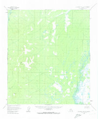
1953 Map of Kantishna River A-6
USGS Topo · Published 1973About this map
Sischu Mountain dominates the western landscape of this mid-century survey, rising above a vast network of wetlands and meandering waterways. To the east, the North Fork Kuskokwim River carves a complex path through the lowlands, its braided channels and oxbows indicating a highly dynamic riparian environment. The West Fairbanks Meridian Boundary bisects the rugged terrain, marking a formal division in a wilderness primarily defined by its natural features.
Find a feature on this map
5 named features on this map. Tap any name to fly to it.
Don’t see what you’re looking for? This feature index may not catch every label — zoom into the map to look around manually.
Map Details
Editions of this 1953 Kantishna River A-6 Map
4 editions found
Other maps of this area

1948 · Kantishna River
USGS Topo · 1:250,000

1950 · Medfra
USGS Topo · 1:250,000

1951 · Kantishna River
USGS Topo · 1:250,000

1951 · Ruby
USGS Topo · 1:250,000

1952 · Mount McKinley
USGS Topo · 1:250,000

1952 · Ruby B-1
USGS Topo · 1:63,360

1952 · Ruby A-1
USGS Topo · 1:63,360

1952 · Kantishna River
USGS Topo · 1:250,000

1952 · Kantishna River B-6
USGS Topo · 1:63,360

1952 · Kantishna River A-5
USGS Topo · 1:63,360