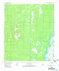
1953 Map of Kantishna River A-6
USGS Topo · Published 1983About this map
The Sischu Mountains dominate this interior Alaskan landscape, providing a high-altitude contrast to the complex drainage systems that define the surrounding lowlands. Mapped from aerial photography taken in 1952, the sheet documents a wilderness area where water shapes the topography, notably through the meandering path of the North Fork Kuskokwim River as it winds through a dense network of wetlands and small lakes. In the northwest, the Sethkokna River enters the frame, while Sischu Creek drains the slopes near Sischu Mountain. This 1:63,360 scale survey illustrates a region without roads or established settlements, focusing instead on the precise natural landmarks and watercourses that served as the primary navigation points for early travelers and surveyors in the Yukon-Koyukuk region.
Find a feature on this map
7 named features on this map. Tap any name to fly to it.
Don’t see what you’re looking for? This feature index may not catch every label — zoom into the map to look around manually.
Map Details
Editions of this 1953 Kantishna River A-6 Map
4 editions found
Other maps of this area

1948 · Kantishna River
USGS Topo · 1:250,000

1950 · Medfra
USGS Topo · 1:250,000

1951 · Kantishna River
USGS Topo · 1:250,000

1951 · Ruby
USGS Topo · 1:250,000

1952 · Mount McKinley
USGS Topo · 1:250,000

1952 · Ruby B-1
USGS Topo · 1:63,360

1952 · Ruby A-1
USGS Topo · 1:63,360

1952 · Kantishna River
USGS Topo · 1:250,000

1952 · Kantishna River B-6
USGS Topo · 1:63,360

1952 · Kantishna River A-5
USGS Topo · 1:63,360