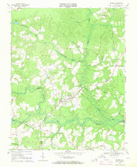
1969 Map of Dendron
USGS Topo · Published 1971About this map
Dendron serves as the central hub of this Southside Virginia landscape, situated along the boundary where Surry and Sussex counties meet. The area is defined by an intricate network of wetlands, including the broad Cypress Swamp, Johnchecohunk Swamp, and Pigeonroost Swamp, which all feed into the Blackwater River at the south. This environment dictated a settlement pattern of small crossroads and family-named corners rather than dense urban growth.
Find a feature on this map
36 named features on this map. Tap any name to fly to it.
Don’t see what you’re looking for? This feature index may not catch every label — zoom into the map to look around manually.
Map Details
Editions of this 1969 Dendron Map
2 editions found
Other maps of this area

1919 · Surry
USGS Topo · 1:62,500

1919 · Disputanta
USGS Topo · 1:62,500

1919 · Homeville
USGS Topo · 1:48,000

1920 · Ivor
USGS Topo · 1:62,500

1920 · Homeville
USGS Topo · 1:62,500

1943 · Manry
USGS Topo · 1:31,680

1943 · Savedge
USGS Topo · 1:31,680

1943 · Richmond
USGS Topo · 1:250,000

1944 · Waverly
USGS Topo · 1:31,680

1944 · Ivor
USGS Topo · 1:24,000