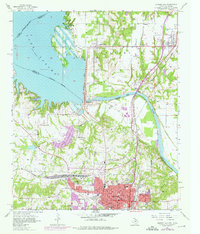
1957 Map of Denison Dam
USGS Topo · Published 1976About this map
Lake Texoma and the Denison Dam anchor this landscape, illustrating the engineering of the mid-20th century. The reservoir covers substantial territory along the Texas-Oklahoma border, fed by the Red River and smaller tributaries like Burns Run and Sand Creek. In Denison, the urban grid is dense with civic and educational infrastructure, including City Hall, Houston Sch, and Raynal Sch. The industrial and transportation legacy of the region is evident in the multiple rail lines, such as the St Louis San Francisco and Missouri Kansas Texas, which intersect at Staley. Beyond the city limits, the landscape transitions into a mix of gravel pits and rural settlements like Colbert and Pickwick, while local history is preserved at Fairview Cemetery and the Garden of Memory Cem.
Find a feature on this map
39 named features on this map. Tap any name to fly to it.
Don’t see what you’re looking for? This feature index may not catch every label — zoom into the map to look around manually.
Map Details
Editions of this 1957 Denison Dam Map
3 editions found
Other maps of this area

1901 · Denison
USGS Topo · 1:125,000

1954 · Sherman
USGS Topo · 1:250,000

1957 · Denison Dam
USGS Topo · 1:24,000

1958 · Durant
USGS Topo · 1:62,500

1958 · Whitesright
USGS Topo · 1:62,500

1958 · Denison Dam
USGS Topo · 1:62,500

1958 · Sherman NW
USGS Topo · 1:24,000

1958 · Sherman
USGS Topo · 1:250,000

1958 · Sherman
USGS Topo · 1:62,500

1958 · Sherman
USGS Topo · 1:24,000