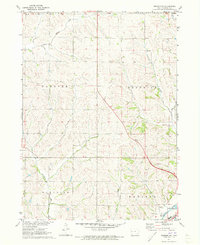
1971 Map of Denison SW
USGS Topo · Published 1973About this map
The Boyer River corridor anchors the southeastern corner of this Crawford County landscape, where the C & Nw railroad tracks parallel the water through a valley defined by the Denison and Paradise townships. This 1971 survey captures the agricultural heart of western Iowa, characterized by the intricate drainage systems of East Soldier River, Buffalo Creek, and Paradise Creek. Infrastructure to support the growing regional economy is evident through the presence of a Gaging Station and a Gravel Pit, alongside municipal developments like Sewage Disposal Ponds. The map provides a look at the township boundaries of Morgan, Hanover, and Goodrich, tracing the section lines and rural road networks that structured Iowa's family farms in the early 1970s.
Find a feature on this map
17 named features on this map. Tap any name to fly to it.
Don’t see what you’re looking for? This feature index may not catch every label — zoom into the map to look around manually.
Map Details
Editions of this 1971 Denison SW Map
This is the sole edition of this map. No revisions or reprints were ever made.
Other maps of this area

1954 · Omaha
USGS Topo · 1:250,000

1954 · Fort Dodge
USGS Topo · 1:250,000

1957 · Omaha
USGS Topo · 1:250,000

1957 · Fort Dodge
USGS Topo · 1:250,000

1958 · Omaha
USGS Topo · 1:250,000

1958 · Fort Dodge
USGS Topo · 1:250,000

1971 · Ricketts
USGS Topo · 1:24,000

1971 · Schleswig
USGS Topo · 1:24,000

1971 · Earling NE
USGS Topo · 1:24,000

1971 · Denison
USGS Topo · 1:24,000