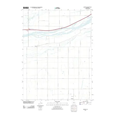
2011 Map of Denman
USGS Topo · Published 2011About this map
The braided waters of the Middle Channel Platte River and South Channel Platte River dominate the northern landscape of this Platte Valley region. At the dawn of the 21st century, the area maintains its agricultural character, structured by a rigorous grid of section roads including W Lochland Rd and W 70th St. The settlement of Denman sits north of the river channels, while Kenesaw anchors the southern boundary of the map. This survey documents the intersection of modern transport and natural hydrology, where the I 80 Access Rd cuts across the river flats. Smaller drainages like Dry Creek and the West Branch Thirtytwo Mile Creek flow through the southern township, tracing the subtle elevation changes of the Nebraska plains. Local roads often carry family or regional names, such as Wiseman Rd and N Shiloh Ave, which serve as vital markers for genealogical research in Adams County.
Find a feature on this map
39 named features on this map. Tap any name to fly to it.
Don’t see what you’re looking for? This feature index may not catch every label — zoom into the map to look around manually.
Map Details
Editions of this 2011 Denman Map
This is the sole edition of this map. No revisions or reprints were ever made.
Other maps of this area

1894 · Kenesaw
USGS Topo · 1:62,500

1894 · Minden
USGS Topo · 1:62,500

1895 · Wood River
USGS Topo · 1:62,500

1896 · Wood River
USGS Topo · 1:125,000

1955 · Grand Island
USGS Topo · 1:250,000

1957 · Grand Island
USGS Topo · 1:250,000

1958 · Grand Island
USGS Topo · 1:250,000

1962 · Denman
USGS Topo · 1:24,000

1962 · Prosser
USGS Topo · 1:24,000
1962 · Gibbon North
USGS Topo · 1:24,000