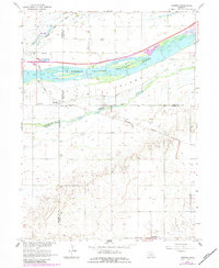
1962 Map of Denman
USGS Topo · Published 1984About this map
The braided channels of the Platte River dominate this landscape on the border of Buffalo, Hall, Adams, and Kearney Counties. The water divides into the North Channel Platte River, the Middle Channel Platte River, and the South Channel Platte River, creating a complex network of sandbars and landforms including the large Elm Island. Human settlement is concentrated around the small community of Denman, where the Union Pacific railroad corridor runs parallel to the river's path. Rural education and local industry are marked by the presence of School No 37 and a Gravel Pit near the northern riverbank. South of the river, the terrain transitions into more defined drainage patterns like Dry Creek, illustrating the intersection of the river's alluvial system with the surrounding agricultural prairie in the early 1960s.
Find a feature on this map
15 named features on this map. Tap any name to fly to it.
Don’t see what you’re looking for? This feature index may not catch every label — zoom into the map to look around manually.
Map Details
Editions of this 1962 Denman Map
3 editions found
Other maps of this area

1894 · Kenesaw
USGS Topo · 1:62,500

1894 · Minden
USGS Topo · 1:62,500

1895 · Wood River
USGS Topo · 1:62,500

1896 · Wood River
USGS Topo · 1:125,000

1955 · Grand Island
USGS Topo · 1:250,000

1957 · Grand Island
USGS Topo · 1:250,000

1958 · Grand Island
USGS Topo · 1:250,000

1962 · Denman
USGS Topo · 1:24,000

1962 · Prosser
USGS Topo · 1:24,000
1962 · Gibbon North
USGS Topo · 1:24,000