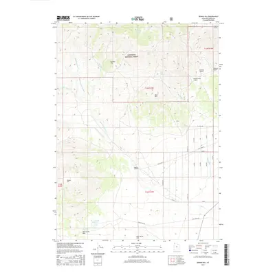
2017 Map of Dennis Hill
USGS Topo · Published 2017About this map
The Sawtooth National Forest dominates the high-elevation northern landscape of this region in Box Elder County, where multiple canyons and hollows converge. High points like Dennis Hill and the Nut Pine Hills transition into a structured drainage system defined by the Right Hand Fork Dove Cr and the Left Hand Fork Dove Cr. These waterways feed into the southern basin, where the Warm Spring Reservoir and Warm Spring Wash provide essential water resources for this arid environment. To the east, the terrain levels out into a grid of rural roads such as Dove Creek Rd and N 62000 W Rd. Genealogists and local historians can trace family-named features like Suzanna Canyon, Danish Hollow, and Corner Creek Canyon that reflect the ranching and settlement patterns of the northwestern Utah desert.
Find a feature on this map
35 named features on this map. Tap any name to fly to it.
Don’t see what you’re looking for? This feature index may not catch every label — zoom into the map to look around manually.
Map Details
Editions of this 2017 Dennis Hill Map
This is the sole edition of this map. No revisions or reprints were ever made.
Other maps of this area

1954 · Brigham City
USGS Topo · 1:250,000

1958 · Brigham City
USGS Topo · 1:250,000

1959 · Park Valley
USGS Topo · 1:62,500

1959 · Yost
USGS Topo · 1:62,500

1962 · Brigham City
USGS Topo · 1:250,000

1971 · Potters Creek
USGS Topo · 1:24,000
1971 · Runswick Wash
USGS Topo · 1:24,000

1971 · Warm Spring Hills
USGS Topo · 1:24,000

1987 · Grouse Creek
USGS Topo · 1:100,000
1990 · Dennis Hill
USGS Topo · 1:24,000