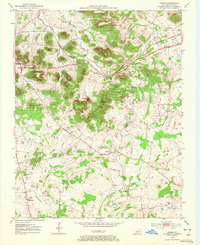
1952 Map of Dennis
USGS Topo · Published 1972About this map
Mud River and its meandering tributaries define the landscape of northern Logan County in the early 1950s. The area is characterized by a high density of rural institutions that once served as the social backbone of this agricultural community, including the Mud River Valley Sch and numerous country churches like Corinth Ch and Bibbs Chapel. The terrain transitions from the lowlands of Whippoorwill Creek and Pleasant Run to the prominent heights of Sugarloaf Knob, Rainbow Rock, and Buzzard Knob. This survey captures the small settlements of Dennis and Halls Store connected by the Louisville and Nashville Highway, preserving the locations of family-named sites such as Cook Cem and Bibbs Chapel Cem during a period of traditional land use before modern development.
Find a feature on this map
18 named features on this map. Tap any name to fly to it.
Don’t see what you’re looking for? This feature index may not catch every label — zoom into the map to look around manually.
Map Details
Editions of this 1952 Dennis Map
3 editions found
Other maps of this area

1942 · Gallatin
USGS Topo · 1:100,000

1951 · Adairville
USGS Topo · 1:24,000

1951 · Dot
USGS Topo · 1:24,000

1951 · Prices Mill
USGS Topo · 1:24,000

1951 · Auburn
USGS Topo · 1:24,000

1951 · Lewisburg
USGS Topo · 1:24,000

1951 · South Union
USGS Topo · 1:24,000

1951 · Homer
USGS Topo · 1:24,000

1952 · Russellville
USGS Topo · 1:24,000

1952 · Dennis
USGS Topo · 1:24,000