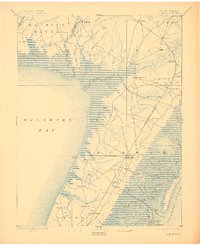
1894 Map of Dennisville
USGS Topo · Published 1910About this map
Great Cedar Swamp dominates the interior of this late 19th-century coastal survey, illustrating a landscape defined by the drainage of Dennis Creek and the Maurice River. The area serves as a critical transportation corridor for the West Jersey Railroad, with key hubs at Sea Isle Junction and Anglesea Junction facilitating movement between inland settlements and the Atlantic coast. Coastal life is centered around numerous landings, including Goshen Landing and Shell Landing, which connect the mainland to the complex waterway systems of Jenkins Sound and Grassy Sound. The presence of Formosa Bogs and the Hereford L.S.S. life-saving station highlights the dual nature of this environment, supporting both specialized agriculture and maritime safety along the shifting sands of Seven Mile Beach.
Find a feature on this map
86 named features on this map. Tap any name to fly to it.
Don’t see what you’re looking for? This feature index may not catch every label — zoom into the map to look around manually.
Map Details
Editions of this 1894 Dennisville Map
4 editions found

Other maps of this area

1884 · Sea Isle
USGS Topo · 1:62,500

1888 · Cape May
USGS Topo · 1:62,500

1888 · Dennisville
USGS Topo · 1:62,500

1888 · Sea Isle
USGS Topo · 1:62,500

1890 · Great Egg Harbor
USGS Topo · 1:62,500

1890 · Tuckahoe
USGS Topo · 1:62,500

1890 · Maurice Cove
USGS Topo · 1:62,500

1890 · Bridgeton
USGS Topo · 1:62,500

1891 · Maurice Cove
USGS Topo · 1:62,500

1893 · Cape May
USGS Topo · 1:62,500
Featured Places
- Lower Township, NJ
- Middle Township, NJ
- Upper Township, NJ
- Villas, Lower Township
- Maurice River Township, NJ