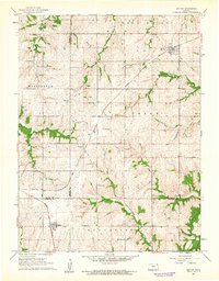
1961 Map of Denton
USGS Topo · Published 1962About this map
Denton sits at a major rail junction in the northeast corner of this 1961 survey, where the Chicago Rock Island and Pacific railroad cuts a diagonal path through the Kansas prairie. The landscape is defined by the convergence of several county lines, including the borders of Washington, Union, and Lancaster townships. This agricultural area is deeply etched by the Wolf River and its tributaries, such as Halling Creek and the South Fork Wolf River. A notable concentration of community landmarks, including Denton Cem, St Marys Cem, and Anderson Cem, provides critical data for genealogists. The map also documents rural infrastructure like the High Prairie Sch and local industry via a Gravel Pit, offering a detailed view of the regional economy and social layout before late-century rural shifts.
Find a feature on this map
21 named features on this map. Tap any name to fly to it.
Don’t see what you’re looking for? This feature index may not catch every label — zoom into the map to look around manually.
Map Details
Editions of this 1961 Denton Map
2 editions found
Other maps of this area

1885 · Atchison
USGS Topo · 1:125,000

1888 · Atchison
USGS Topo · 1:125,000

1893 · Atchison
USGS Topo · 1:125,000

1926 · Atchison
USGS Topo · 1:62,500

1926 · Oregon
USGS Topo · 1:62,500

1950 · Kansas City
USGS Topo · 1:250,000

1954 · Kansas City
USGS Topo · 1:250,000

1956 · Kansas City
USGS Topo · 1:250,000
1959 · Sparks
USGS Topo · 1:24,000
1959 · Bendena
USGS Topo · 1:24,000