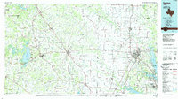
1985 Map of Denton
USGS Topo · Published 1985About this map
Denton and Decatur anchor this mid-1980s landscape, a period when the North Texas corridor was seeing significant expansion. The map detail highlights the rail-dependent growth of the era, following the lines of the Burlington Northern, Missouri-Kansas-Texas, and Santa Fe railroads as they connect rural outposts like Bolivar and Justin to the larger municipal centers. Water management and recreation are central to the region’s layout, dominated by the massive reservoirs of Lake Bridgeport in the west and Lewisville Lake in the east.
Find a feature on this map
159 named features on this map. Tap any name to fly to it.
Don’t see what you’re looking for? This feature index may not catch every label — zoom into the map to look around manually.
Map Details
Editions of this 1985 Denton Map
This is the sole edition of this map. No revisions or reprints were ever made.
Other maps of this area

1891 · Weatherford
USGS Topo · 1:125,000

1891 · Dallas
USGS Topo · 1:125,000

1891 · Palo Pinto
USGS Topo · 1:125,000

1893 · Dallas
USGS Topo · 1:125,000

1893 · Weatherford
USGS Topo · 1:125,000

1894 · Fort Worth
USGS Topo · 1:125,000

1901 · Denison
USGS Topo · 1:125,000

1902 · Gainesville
USGS Topo · 1:125,000

1905 · Montague
USGS Topo · 1:125,000

1918 · Palo Pinto
USGS Topo · 1:125,000