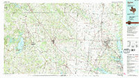
1991 Map of Denton
USGS Topo · Published 1991About this map
Decatur and Denton serve as primary hubs in this regional overview of North Texas during the early 1990s. The landscape is defined by the three major reservoirs of Lake Bridgeport, Lewisville Lake, and Grapevine Lake, which anchor the water system for the surrounding communities. A dense transportation corridor of interstate and U.S. highways, including I-35, U.S. 380, and U.S. 287, facilitates travel between smaller rural settlements like Chico, Krum, and Alvord. Heavy rail operations by the Burlington Northern and Missouri Pacific lines highlight the era's ongoing industrial and agricultural logistics. Smaller, more isolated landmarks such as Wizard Wells and Lucky Ridge provide detail on the more rural stretches between the expanding urban centers.
Find a feature on this map
92 named features on this map. Tap any name to fly to it.
Don’t see what you’re looking for? This feature index may not catch every label — zoom into the map to look around manually.
Map Details
Editions of this 1991 Denton Map
2 editions found
Other maps of this area

1891 · Weatherford
USGS Topo · 1:125,000

1891 · Dallas
USGS Topo · 1:125,000

1891 · Palo Pinto
USGS Topo · 1:125,000

1893 · Dallas
USGS Topo · 1:125,000

1893 · Weatherford
USGS Topo · 1:125,000

1894 · Fort Worth
USGS Topo · 1:125,000

1901 · Denison
USGS Topo · 1:125,000

1902 · Gainesville
USGS Topo · 1:125,000

1905 · Montague
USGS Topo · 1:125,000

1918 · Palo Pinto
USGS Topo · 1:125,000