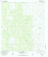
1984 Map of Dentonio
USGS Topo · Published 1984About this map
The small settlement of Dentonio anchors this South Texas landscape in the mid-1980s, situated within the brush country of Dimmit County. The terrain is defined by an intricate network of seasonal drainages, most notably San Lorenzo Creek and El Moro Creek, which feed into numerous man-made livestock watering points or "tanks." These water features, such as Coal Mine Tank and Old Tresquilla Tank, reflect the ranching economy and land use patterns of the region.
Find a feature on this map
10 named features on this map. Tap any name to fly to it.
Don’t see what you’re looking for? This feature index may not catch every label — zoom into the map to look around manually.
Map Details
Editions of this 1984 Dentonio Map
This is the sole edition of this map. No revisions or reprints were ever made.
Other maps of this area

1929 · Cotulla
USGS Topo · 1:125,000

1940 · Asherton
USGS Topo · 1:62,500

1940 · San Loranzo Creek
USGS Topo · 1:62,500

1940 · Chupadera
USGS Topo · 1:62,500

1941 · Botella Creek
USGS Topo · 1:62,500

1953 · Crystal City
USGS Topo · 1:250,000

1955 · Crystal City
USGS Topo · 1:250,000

1957 · Botella Creek
USGS Topo · 1:62,500

1958 · Eagle Pass
USGS Topo · 1:250,000

1961 · Crystal City
USGS Topo · 1:250,000