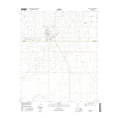
2016 Map of Denver City
USGS Topo · Published 2016About this map
Denver City serves as the focal point of this 2016 survey, situated just north of the Yoakum Co Gaines Co line. The map illustrates a methodical grid of streets ranging from W 11th St to the south, integrated with residential thoroughfares like Western Ave and Belair Ave. The local infrastructure is further defined by the Denver City Airport and a series of rural roads that extend into the surrounding plains. The topographic detail reveals the subtle drainage of McKenzie Draw in the northeastern quadrant, providing context for the hydraulic character of this West Texas landscape. This sheet records the modern layout of a community built on a rigorous spatial plan, where major arteries such as E Broadway St facilitate movement across the county boundary.
Find a feature on this map
87 named features on this map. Tap any name to fly to it.
Don’t see what you’re looking for? This feature index may not catch every label — zoom into the map to look around manually.
Map Details
Editions of this 2016 Denver City Map
This is the sole edition of this map. No revisions or reprints were ever made.
Other maps of this area

1954 · Hobbs
USGS Topo · 1:250,000

1954 · Brownfield
USGS Topo · 1:250,000

1958 · Brownfield
USGS Topo · 1:250,000

1958 · Hobbs
USGS Topo · 1:250,000

1962 · Brownfield
USGS Topo · 1:250,000

1970 · Seagraves SW
USGS Topo · 1:24,000

1970 · Pleasant Hill
USGS Topo · 1:24,000

1970 · Seagraves NW
USGS Topo · 1:24,000

1971 · Higginbotham
USGS Topo · 1:24,000
1971 · Ink Basin
USGS Topo · 1:24,000