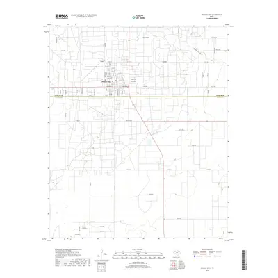
2019 Map of Denver City
USGS Topo · Published 2019About this map
Denver City serves as the focal point of this South Plains landscape, where the town’s grid is defined by a dense network of residential streets such as W 12th St and W Broadway St. The geography is characteristic of the Llano Estacado, featuring the subtle depression of McKenzie Draw cutting through the northeastern quadrant. Modern infrastructure is prominent, with the Denver City Airport situated just north of the town center and a rigorous system of rural routes, including Ranch Rd 2056 and numerous county roads like Co Rd 222, that facilitate movement across the Gaines and Yoakum county line. The map reflects a landscape organized around regional transportation and energy-related transit, with the grid-like precision of Western Ave and E Broadway St anchoring the community's development.
Find a feature on this map
88 named features on this map. Tap any name to fly to it.
Don’t see what you’re looking for? This feature index may not catch every label — zoom into the map to look around manually.
Map Details
Editions of this 2019 Denver City Map
This is the sole edition of this map. No revisions or reprints were ever made.
Other maps of this area

1954 · Hobbs
USGS Topo · 1:250,000

1954 · Brownfield
USGS Topo · 1:250,000

1958 · Brownfield
USGS Topo · 1:250,000

1958 · Hobbs
USGS Topo · 1:250,000

1962 · Brownfield
USGS Topo · 1:250,000

1970 · Seagraves SW
USGS Topo · 1:24,000

1970 · Pleasant Hill
USGS Topo · 1:24,000

1970 · Seagraves NW
USGS Topo · 1:24,000

1971 · Higginbotham
USGS Topo · 1:24,000
1971 · Ink Basin
USGS Topo · 1:24,000