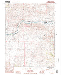
1985 Map of Derby Dam
USGS Topo · Published 1985About this map
The Truckee River carves a critical corridor between the Pah Rah Range and the Virginia Range in this mid-1980s topographical survey. This canyon serves as a major infrastructure artery, carrying the Southern Pacific railroad and Interstate 80 alongside historical transportation routes. Significant among these are the Emigrant Trail and California Trail, marking the enduring path of westward migration through Nevada. At the center of the map, Derby Dam diverts water into the Truckee Canal, an early 20th-century engineering feat of the Newlands Project. Industrial activity is evident at the Celatom Mine and several Tailings Ponds, while small settlements like Clark and Thisbe occupy the narrow valley floor near the Washoe and Storey County line.
Find a feature on this map
23 named features on this map. Tap any name to fly to it.
Don’t see what you’re looking for? This feature index may not catch every label — zoom into the map to look around manually.
Map Details
Editions of this 1985 Derby Dam Map
2 editions found
Other maps of this area

1890 · Wadsworth
USGS Topo · 1:125,000

1891 · Carson
USGS Topo · 1:125,000

1891 · Wabuska
USGS Topo · 1:125,000

1891 · Reno
USGS Topo · 1:125,000

1892 · Wadsworth
USGS Topo · 1:125,000

1893 · Carson
USGS Topo · 1:125,000

1893 · Reno
USGS Topo · 1:125,000

1894 · Wadsworth
USGS Topo · 1:125,000

1894 · Wabuska
USGS Topo · 1:125,000

1950 · Virginia City
USGS Topo · 1:62,500