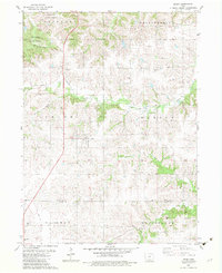
1982 Map of Derby
USGS Topo · Published 1983About this map
Derby serves as the central hub of this 1982 survey, situated amidst the rolling agricultural lands of southern Iowa. The landscape is deeply carved by the Chariton River and its tributaries, including Hamilton Creek and Fivemile Creek, which dictate the local topography and drainage patterns. For local historians and genealogists, the map is remarkably detailed with family-named landmarks and rural burial grounds, such as Webb Cem, Murray Cem, and Woods Cem, alongside the small country Eden Ch. A notable recreational and environmental feature is the presence of Stephens State Forest in the northern sections, while The Cinder Path follows an old railroad alignment through the region, marking the transition from industrial transport to modern conservation and trail use.
Find a feature on this map
24 named features on this map. Tap any name to fly to it.
Don’t see what you’re looking for? This feature index may not catch every label — zoom into the map to look around manually.
Map Details
Editions of this 1982 Derby Map
This is the sole edition of this map. No revisions or reprints were ever made.
Other maps of this area

1918 · Chariton
USGS Topo · 1:62,500

1934 · Humeston
USGS Topo · 1:48,000

1937 · Corydon
USGS Topo · 1:62,500

1950 · New Virginia
USGS Topo · 1:62,500

1952 · New Virginia
USGS Topo · 1:62,500

1954 · Centerville
USGS Topo · 1:250,000

1954 · Des Moines
USGS Topo · 1:250,000

1956 · Des Moines
USGS Topo · 1:250,000

1957 · Des Moines
USGS Topo · 1:250,000

1957 · Centerville
USGS Topo · 1:250,000