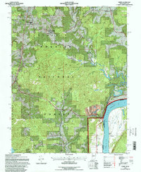
1993 Map of Derby
USGS Topo · Published 1998About this map
The Ohio River forms a dominant eastern boundary in this riverfront area of Perry County, where the settlement of Derby sits along the banks across from Chenaultt in Kentucky. The landscape is defined by the heavy timber of the Hoosier National Forest, which covers much of the interior hills and ridges such as Mogan Ridge and Kuntz Ridge. This 1993 revision, based on earlier surveys and field checks, shows a rural community structure centered around small nodes like Leopold, which is anchored by St Augustine Ch.
Find a feature on this map
53 named features on this map. Tap any name to fly to it.
Don’t see what you’re looking for? This feature index may not catch every label — zoom into the map to look around manually.
Map Details
Editions of this 1993 Derby Map
This is the sole edition of this map. No revisions or reprints were ever made.
Other maps of this area

1928 · Hardinsburg
USGS Topo · 1:48,000

1931 · Hardinsburg
USGS Topo · 1:62,500

1934 · Cannelton
USGS Topo · 1:62,500

1947 · Lodiburg
USGS Topo · 1:24,000

1947 · Hardinsburg
USGS Topo · 1:62,500

1949 · Cannelton
USGS Topo · 1:24,000

1950 · Beechwood
USGS Topo · 1:24,000

1950 · Alton
USGS Topo · 1:62,500

1950 · Alton
USGS Topo · 1:24,000

1951 · Alton
USGS Topo · 1:24,000