
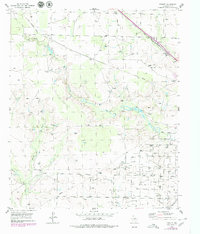
1954 Map of Dermott
USGS Topo · Published 1955About this map
The Kelly Snyder Oil Field dominates the southeastern quadrant of this Scurry County landscape, revealing an intensive industrial footprint defined by a dense grid of oil wells, tanks, and service roads. This energy production zone contrasts sharply with the winding, eroded terrain of the north and west, where Deep Creek and Mooar Draw carve intricate paths through the West Texas earth. Transportation history is etched into the land via the Panhandle and Santa Fe railroad line passing through Dermott, while a prominent Old Railroad Grade further west traces a defunct corridor of commerce. Local infrastructure is further detailed by a network of pipelines, scattered Caliche Pits, and a Landing Strip (Private), illustrating the mid-century transition from traditional ranching and rail to a petroleum-driven economy.
Find a feature on this map
11 named features on this map. Tap any name to fly to it.
Don’t see what you’re looking for? This feature index may not catch every label — zoom into the map to look around manually.
Map Details
Editions of this 1954 Dermott Map
2 editions found
Other maps of this area

1951 · Ira NW
USGS Topo · 1:24,000

1952 · Snyder
USGS Topo · 1:24,000

1952 · Ira NE
USGS Topo · 1:24,000

1954 · Brand
USGS Topo · 1:24,000

1954 · Big Spring
USGS Topo · 1:250,000

1958 · Big Spring
USGS Topo · 1:250,000

1969 · Arah
USGS Topo · 1:24,000

1969 · Fluvanna
USGS Topo · 1:24,000

1969 · Flat Top Mountain
USGS Topo · 1:24,000
1969 · McKenzie Mountains
USGS Topo · 1:24,000