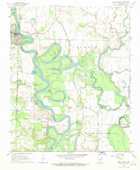
1968 Map of Des Arc East
USGS Topo · Published 1969About this map
The White River meanders through the heart of this Prairie County landscape, creating a complex network of oxbows and sloughs that define the region's geography. The town of Des Arc sits prominently on the western bank, supported by infrastructure like the Pumping Station and Gaging Sta. The winding river channel has left behind numerous named water bodies, including Horseshoe Lake, Alligator Lake, and Spring Lake, illustrating a landscape in constant flux. To the east, the terrain transitions into the Cypress Swamp and the bottomlands of the Cache River, where features like Culotches Bay and Beaver Bayou weave through the low-lying ground.
Find a feature on this map
50 named features on this map. Tap any name to fly to it.
Don’t see what you’re looking for? This feature index may not catch every label — zoom into the map to look around manually.
Map Details
Editions of this 1968 Des Arc East Map
This is the sole edition of this map. No revisions or reprints were ever made.
Other maps of this area

1932 · Kensett
USGS Topo · 1:62,500

1935 · Kensett
USGS Topo · 1:62,500

1935 · Hazen
USGS Topo · 1:62,500

1935 · Gregory
USGS Topo · 1:62,500

1941 · Hazen
USGS Topo · 1:62,500

1941 · De Valls Bluff
USGS Topo · 1:62,500

1948 · Helena
USGS Topo · 1:250,000

1950 · Helena
USGS Topo · 1:250,000

1953 · Memphis
USGS Topo · 1:250,000

1955 · Helena
USGS Topo · 1:250,000