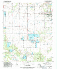
1994 Map of Des Arc West
USGS Topo · Published 1994About this map
The western outskirts of Des Arc are defined by a complex network of bayous and aquaculture in this mid-1990s survey. The landscape transitions from the concentrated settlement at the river bend toward the expansive Wattensaw State Game Area to the south. Distinctive land use patterns are evident in the numerous large Fish Farm operations and Fish Farms that occupy the low-lying areas near Whippoorwill Creek and Big Creek.
Find a feature on this map
32 named features on this map. Tap any name to fly to it.
Don’t see what you’re looking for? This feature index may not catch every label — zoom into the map to look around manually.
Map Details
Editions of this 1994 Des Arc West Map
This is the sole edition of this map. No revisions or reprints were ever made.
Other maps of this area

1932 · Kensett
USGS Topo · 1:62,500

1935 · Kensett
USGS Topo · 1:62,500

1935 · Hazen
USGS Topo · 1:62,500

1935 · Gregory
USGS Topo · 1:62,500

1941 · Hazen
USGS Topo · 1:62,500

1941 · De Valls Bluff
USGS Topo · 1:62,500

1948 · Helena
USGS Topo · 1:250,000

1950 · Helena
USGS Topo · 1:250,000

1953 · Memphis
USGS Topo · 1:250,000

1955 · Helena
USGS Topo · 1:250,000