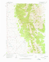
1955 Map of Deseret Peak
USGS Topo · Published 1961About this map
The high ridges of Deseret Peak and Vickory Mtn dominate this mid-century survey of Tooele County, where the transition from the Wasatch National Forest to the arid floor of Skull Valley is clearly defined. The landscape is marked by a network of ranching and mining activity, with isolated outposts such as Hatch Ranch, Deseret Ranch, and Condie Ranch positioned along the valley fringes. Water management is critical in this environment, evidenced by named sources like North Willow Lake, Scribner Spring, and Willow Patch Spring that supported livestock and local industry.
Find a feature on this map
92 named features on this map. Tap any name to fly to it.
Don’t see what you’re looking for? This feature index may not catch every label — zoom into the map to look around manually.
Map Details
Editions of this 1955 Deseret Peak Map
2 editions found
Other maps of this area

1885 · Tooele Valley
USGS Topo · 1:250,000

1918 · Stockton
USGS Topo · 1:62,500

1953 · Tooele
USGS Topo · 1:250,000

1955 · Tabbys Peak SE
USGS Topo · 1:24,000

1955 · Camels Back Ridge NE
USGS Topo · 1:24,000

1955 · Davis Knolls
USGS Topo · 1:24,000

1955 · Timpie
USGS Topo · 1:62,500

1955 · Deseret Peak
USGS Topo · 1:62,500

1955 · Grantsville
USGS Topo · 1:24,000

1955 · Stockton
USGS Topo · 1:62,500