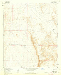
1955 Map of Desert NE
USGS Topo · Published 1962About this map
Water distribution and desert survival define this Otero County landscape, where the Army Map Service captured the terrain's nuances in the mid-1950s. The region is characterized by a reliance on catchments and localized water sources, such as South Well and Alvarado Tank No 2. These points of interest are linked by unimproved dirt roads and fences that slice across the contours, marking the boundaries of ranching or military operations in this corner of New Mexico. Small topographic landmarks like Borrego Tank and School Tank serve as the primary navigational aids in a territory where the natural drainage patterns are more prominent than any permanent settlement. The survey illustrates a high degree of land management through the placement of South Tank and other water features, highlighting the infrastructure required to sustain life and activity in the arid environment.
Find a feature on this map
6 named features on this map. Tap any name to fly to it.
Don’t see what you’re looking for? This feature index may not catch every label — zoom into the map to look around manually.
Map Details
Editions of this 1955 Desert NE Map
2 editions found
Other maps of this area

1940 · Bassett Lake
USGS Topo · 1:62,500

1940 · Orogrande
USGS Topo · 1:62,500

1941 · Desert
USGS Topo · 1:62,500

1943 · Pendejo Wash
USGS Topo · 1:62,500

1943 · Desert
USGS Topo · 1:62,500

1943 · Bassett Lake
USGS Topo · 1:62,500

1943 · Orogrande
USGS Topo · 1:62,500

1947 · Desert NE
USGS Topo · 1:24,000

1948 · El Wood
USGS Topo · 1:24,000
1948 · Desert
USGS Topo · 1:24,000