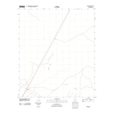
2010 Map of Desert
USGS Topo · Published 2010About this map
The Tularosa Valley landscape is defined by its arid character and sparse infrastructure in this modern survey of south-central New Mexico. The small settlement of Alvarado sits in the southwestern portion of the map, while the named location of Desert is positioned further north along the primary transportation route. The terrain is marked by subtle relief, including the landmark known as Three Buttes in the southeast. This map captures the region at a time when the vast basin remains largely open, characterized by straight-line roads and a distinct lack of dense development. It provides an accurate representation of the physical geography and established place names within Otero County during the early twenty-first century.
Find a feature on this map
4 named features on this map. Tap any name to fly to it.
Don’t see what you’re looking for? This feature index may not catch every label — zoom into the map to look around manually.
Map Details
Editions of this 2010 Desert Map
This is the sole edition of this map. No revisions or reprints were ever made.
Other maps of this area

1940 · Orogrande
USGS Topo · 1:62,500

1940 · Newman
USGS Topo · 1:62,500

1941 · Desert
USGS Topo · 1:62,500

1943 · Parker Lake
USGS Topo · 1:62,500

1943 · Desert
USGS Topo · 1:62,500

1943 · Newman
USGS Topo · 1:62,500

1943 · Orogrande
USGS Topo · 1:62,500

1947 · Desert NE
USGS Topo · 1:24,000

1948 · El Wood
USGS Topo · 1:24,000
1948 · Desert
USGS Topo · 1:24,000