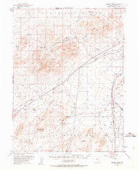
1951 Map of Desert Peak
USGS Topo · Published 1964About this map
The Trinity Range and Hot Springs Mountains dominate this 1951 survey of Churchill and Pershing Counties, revealing a landscape defined by mining activity and historic migration corridors. Early industrial sites such as the Copper Queen Mine, Mule Train Mines, and various Diatomaceous Quarry locations are scattered across the high desert terrain. The map's eastern edge transitions into the Alkali Flat (Depression) and the Stillwater Wildlife Management Area near the Humboldt Slough, highlighting the stark contrast between the arid peaks and the low-lying sinks.
Find a feature on this map
35 named features on this map. Tap any name to fly to it.
Don’t see what you’re looking for? This feature index may not catch every label — zoom into the map to look around manually.
Map Details
Editions of this 1951 Desert Peak Map
3 editions found

Other maps of this area

1886 · Granite Range
USGS Topo · 1:250,000

1890 · Wadsworth
USGS Topo · 1:125,000

1892 · Wadsworth
USGS Topo · 1:125,000

1894 · Granite Range
USGS Topo · 1:250,000

1894 · Wadsworth
USGS Topo · 1:125,000

1908 · Carson Sink
USGS Topo · 1:250,000

1910 · Carson Sink
USGS Topo · 1:250,000

1931 · Lovelock
USGS Topo · 1:250,000

1935 · Lovelock
USGS Topo · 1:250,000

1950 · Stillwater
USGS Topo · 1:62,500