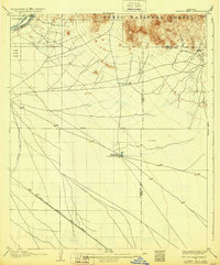
1906 Map of Desert Well
USGS Topo · Published 1928About this map
Buchanan's Ranch and the settlement of Higley anchor this early twentieth-century survey of the arid lands east of Phoenix. The landscape is defined by the early infrastructure of the Salt River Valley, where the Highland Canal and Salt River Consolidated Canal branch off from the Salt River near the Salt River Ind Res. These waterways represent the vital irrigation efforts that transformed the desert into agricultural land. Further east, the terrain rises into the User Mts and Pass Mts within the Tonto National Forest, where the Bulldog Mine indicates early mineral exploration.
Find a feature on this map
24 named features on this map. Tap any name to fly to it.
Don’t see what you’re looking for? This feature index may not catch every label — zoom into the map to look around manually.
Map Details
Editions of this 1906 Desert Well Map
3 editions found
Other maps of this area

1900 · Florence
USGS Topo · 1:125,000

1902 · Florence
USGS Topo · 1:125,000

1904 · Camelback
USGS Topo · 1:62,500

1904 · Desert Well
USGS Topo · 1:62,500

1904 · Ft. McDowell
USGS Topo · 1:62,500

1906 · Camelsback
USGS Topo · 1:62,500

1906 · Ft. McDowell
USGS Topo · 1:62,500

1906 · Desert Well
USGS Topo · 1:62,500

1907 · Sacaton
USGS Topo · 1:62,500

1907 · Roosevelt
USGS Topo · 1:125,000