
1956 Map of Destruction Island
USGS Topo · Published 1959About this map
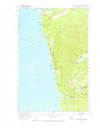
Hoh Indian Reservation and the Queets Indian Reservation anchor this mid-century survey of the Washington coast, where the rainforest meets the Pacific. The landscape is defined by the powerful convergence of the Hoh River, Clearwater River, and Quinault River as they reach the sea. This 1956 survey records a period when coastal access was maintained via a series of numbered trails, including Beach Trail 1 and Beach Trail 5, during the early expansion of Olympic National Park.
Find a feature on this map
60 named features on this map. Tap any name to fly to it.
Don’t see what you’re looking for? This feature index may not catch every label — zoom into the map to look around manually.
Map Details
Editions of this 1956 Destruction Island Map
2 editions found
Other maps of this area

1939 · Forks
USGS Topo · 1:62,500

1943 · Spruce Mountain
USGS Topo · 1:62,500

1943 · Copalis Beach
USGS Topo · 1:250,000

1951 · Copalis Beach
USGS Topo · 1:250,000

1955 · Taholah
USGS Topo · 1:62,500

1955 · Macafee Hill
USGS Topo · 1:62,500

1956 · La Push
USGS Topo · 1:62,500

1956 · Spruce Mtn.
USGS Topo · 1:62,500

1956 · Salmon River
USGS Topo · 1:62,500

1957 · Forks
USGS Topo · 1:62,500