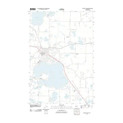
2010 Map of Detroit Lakes
USGS Topo · Published 2010About this map
Detroit Lakes serves as the central hub of this lake-strewn landscape in Becker County, where the city grid is tightly integrated with the northern shore of Detroit Lake. This 2010 survey highlights a community shaped by its proximity to water and recreation, featuring landmarks like the Detroit Lakes Post Office, the Becker County Fairgrounds, and the Holy Rosary Catholic Church. The surrounding terrain is a complex network of glacial hydrology, including Floyd Lake, Abbey Lake, and Schultz Lake, all connected or separated by small waterways like the Pelican River and Sucker Creek Number One.
Find a feature on this map
83 named features on this map. Tap any name to fly to it.
Don’t see what you’re looking for? This feature index may not catch every label — zoom into the map to look around manually.
Map Details
Editions of this 2010 Detroit Lakes Map
This is the sole edition of this map. No revisions or reprints were ever made.
Other maps of this area

1912 · Vergas
USGS Topo · 1:62,500

1915 · Perham
USGS Topo · 1:62,500

1915 · Vergas
USGS Topo · 1:62,500

1953 · Brainerd
USGS Topo · 1:250,000

1957 · Brainerd
USGS Topo · 1:250,000

1958 · Brainerd
USGS Topo · 1:250,000

1959 · Flat Lake
USGS Topo · 1:24,000

1959 · Rochert
USGS Topo · 1:24,000

1959 · Richwood
USGS Topo · 1:24,000
1959 · Callaway
USGS Topo · 1:24,000