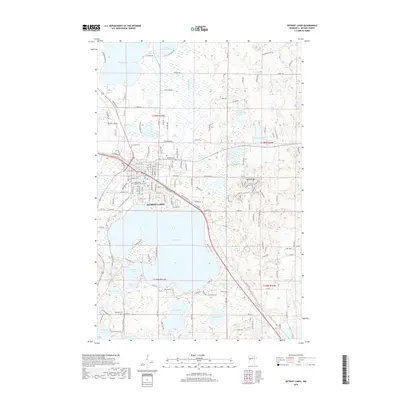
2019 Map of Detroit Lakes
USGS Topo · Published 2019About this map
Detroit Lakes serves as the focal point of this Becker County landscape, where the BNSF Railway corridor and major thoroughfares like Main St W cut through the developed center. The region is defined by its complex glacial hydrology, featuring a dense concentration of water bodies including the expansive Detroit Lake, Floyd Lake, and Abbey Lake. Smaller features like Deadshot Bay and the winding Pelican River suggest a shoreline-driven local economy and geography. For genealogists and local historians, several key burial sites are documented, including Oak Grove Cem and Holy Rosary Catholic Church Cem. To the east, the elevation rises toward Detroit Mtn, while residential expansion is evident along named roads such as Oakland Beach Rd and Little Floyd Lake Rd, showing the modern footprint of this lakeside community.
Find a feature on this map
198 named features on this map. Tap any name to fly to it.
Don’t see what you’re looking for? This feature index may not catch every label — zoom into the map to look around manually.
Map Details
Editions of this 2019 Detroit Lakes Map
This is the sole edition of this map. No revisions or reprints were ever made.
Other maps of this area

1912 · Vergas
USGS Topo · 1:62,500

1915 · Perham
USGS Topo · 1:62,500

1915 · Vergas
USGS Topo · 1:62,500

1953 · Brainerd
USGS Topo · 1:250,000

1957 · Brainerd
USGS Topo · 1:250,000

1958 · Brainerd
USGS Topo · 1:250,000

1959 · Flat Lake
USGS Topo · 1:24,000

1959 · Rochert
USGS Topo · 1:24,000

1959 · Richwood
USGS Topo · 1:24,000
1959 · Callaway
USGS Topo · 1:24,000