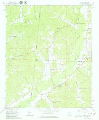
1967 Map of Detroit
USGS Topo · Published 1980About this map
Detroit anchors this landscape where Alabama meets Mississippi, situated just east of the state line and the Old Indian Treaty Boundary. The area is defined by a dense network of waterways including Sipsey Creek, Splunge Creek, and Bluegut Creek, which historically dictated the placement of small rural communities and family cemeteries. Several houses of worship, such as Liberty Grove Ch and Allman Chapel, are scattered among the ridges, while the Byrd Sch and numerous gravel pits suggest a community rooted in local education and resource extraction. The map preserves the exact locations of many family-named burial grounds like Riggins Cem and Thompson Cem, providing essential data for those tracing ancestral footprints in Lamar and Marion counties during the late 1960s.
Find a feature on this map
36 named features on this map. Tap any name to fly to it.
Don’t see what you’re looking for? This feature index may not catch every label — zoom into the map to look around manually.
Map Details
Editions of this 1967 Detroit Map
3 editions found
Other maps of this area

1953 · West Point
USGS Topo · 1:250,000

1956 · Tupelo
USGS Topo · 1:250,000

1958 · Tupelo
USGS Topo · 1:250,000

1958 · West Point
USGS Topo · 1:250,000

1963 · West Point
USGS Topo · 1:250,000

1966 · Turon
USGS Topo · 1:24,000

1966 · Tremont
USGS Topo · 1:24,000

1966 · Greenwood Springs
USGS Topo · 1:24,000

1967 · Sulligent
USGS Topo · 1:24,000
1967 · Weston
USGS Topo · 1:24,000