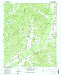
1967 Map of Detroit
USGS Topo · Published 1980About this map
The town of Detroit serves as the focal point for this late-1960s survey along the Alabama-Mississippi state line, where the landscape is defined by the winding course of Sipsey Creek and its many tributaries. A significant historical marker, the Old Indian Treaty Boundary, cuts through the terrain, providing a look at colonial-era land divisions still recognized in the 20th century. This area, spanning the borders of Lamar, Marion, and Monroe counties, is dotted with numerous country churches such as New Macedonia Ch, Allman Chapel, and Friendship North Ch. Genealogists will find particular value in the several family and church cemeteries like Thompson Cem and Riggins Cem that are scattered across the rural countryside. The presence of numerous Gravel Pits along Bluegut Creek and Factory Creek points to the local industry of the era, while the Radio Tower and Water Tank in Detroit mark the mid-century infrastructure of this cross-border community.
Find a feature on this map
34 named features on this map. Tap any name to fly to it.
Don’t see what you’re looking for? This feature index may not catch every label — zoom into the map to look around manually.
Map Details
Editions of this 1967 Detroit Map
3 editions found
Other maps of this area

1953 · West Point
USGS Topo · 1:250,000

1956 · Tupelo
USGS Topo · 1:250,000

1958 · Tupelo
USGS Topo · 1:250,000

1958 · West Point
USGS Topo · 1:250,000

1963 · West Point
USGS Topo · 1:250,000

1966 · Turon
USGS Topo · 1:24,000

1966 · Tremont
USGS Topo · 1:24,000

1966 · Greenwood Springs
USGS Topo · 1:24,000

1967 · Sulligent
USGS Topo · 1:24,000
1967 · Weston
USGS Topo · 1:24,000