
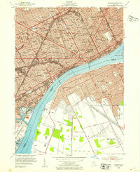
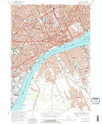
1905 Map of Detroit
USGS Topo · Published 1915About this map
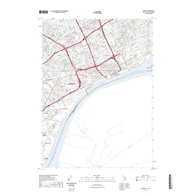
The city of Windsor and Walkerville look across the Detroit River to a rapidly expanding urban core at the turn of the century. This survey documents the transition of outlying townships like Greenfield and Springwells into industrial and residential hubs, long before the consolidation of the modern metro area. A complex web of rail lines, including the Grand Trunk (Detroit and Pontiac Line) and the Detroit Orchard Lake Electric, radiates from the riverfront, illustrating the city's early reliance on heavy rail and electric traction. To the north, Palmer Park and Mt Olivet Cemetery sit at the city's then-fringe, while named locales like Oakwood and Navarre PO mark the settlements along the Rouge River south of Dearborn. The map captures the distinct street grids of Highland Park and Hamtramck as they began to be surrounded by the growing city.
Find a feature on this map
58 named features on this map. Tap any name to fly to it.
Don’t see what you’re looking for? This feature index may not catch every label — zoom into the map to look around manually.
Map Details
Editions of this 1905 Detroit Map
2 editions found

Historical Maps of Detroit Through Time
20 maps found
1905 Detroit
Wayne County, MI

1918 Detroit
Wayne County, MI

1924 Detroit
Wayne County, MI

1934 Detroit
Wayne County, MI

1937 Detroit
Wayne County, MI

1940 Detroit
Wayne County, MI

1947 Detroit
Wayne County, MI
1952 Detroit
Wayne County, MI

1954 Detroit
Wayne County, MI

1954 Detroit
Wayne County, MI

1961 Detroit
Wayne County, MI

1965 Detroit
Wayne County, MI
1968 Detroit
Wayne County, MI

1985 Detroit
Wayne County, MI

1989 Detroit
Wayne County, MI
2011 Detroit
Wayne County, MI
2014 Detroit
Wayne County, MI

2017 Detroit
Wayne County, MI

2019 Detroit
Wayne County, MI
2023 Detroit
Wayne County, MI